Configure Now
Items in Your Cart0
0Items in Your Cart
Start building your packageShop Now
A 24-day Antarctic expedition brought together 25 women explorers from more than nine countries to conduct subsea research using Deep Trekker ROV systems across one of the most remote marine environments on Earth. The mission focused on hydrothermal vent surveying, seafloor mapping, seal behavioural studies, and documentation of historical industrial sites at Deception Island. The work combined underwater robotics with field science to collect high-resolution datasets under extreme polar conditions, supporting ongoing research into climate-driven change and ocean system dynamics.

This case study documents the operational deployment of ROV technology within Antarctic field constraints and its role in enabling integrated subsea data collection across science, mapping, and ecological research workflows.
The Antarctic ROV expedition was a women-led STEM and ocean science program focused on seafloor mapping, hydrothermal vent detection, and marine ecosystem documentation in the Southern Ocean.
A team of 25 women explorers conducted coordinated field operations across Antarctica, South Georgia, and surrounding waters. The program combined science, exploration, and storytelling under the Sea Women Expeditions (SWX) framework, a leadership and ocean research initiative sanctioned as part of the UN Ocean Decade.
The expedition objective included climate change observation and public science communication using GIS-based mapping tools. SWX partnered with Esri Canada, which provided ArcGIS Online and ArcGIS StoryMaps to convert field datasets into interactive spatial narratives.

SWX founder Susan R. Eaton described the purpose of the program:
and added on the role of mapping technology:
“Technology like ArcGIS allows us to combine science, culture and lived experience into powerful, inclusive narratives the world can engage with easily.”
Learn how Parks Canada Uses ROVs to investigate historical wrecks and underwater sites while reducing diver risk and improving survey efficiency and accuracy.
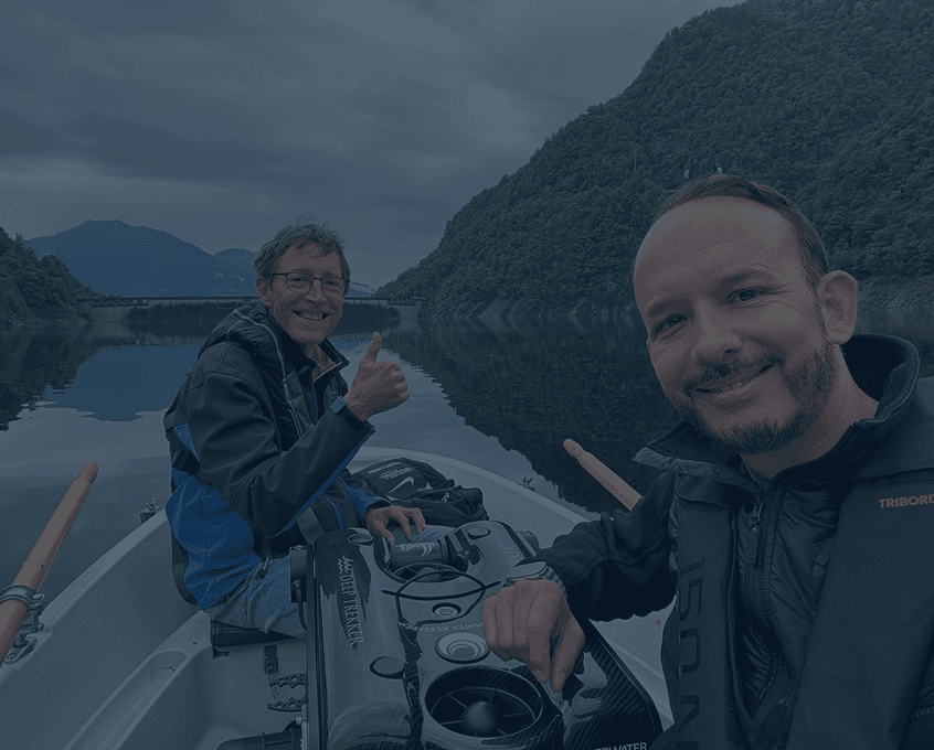
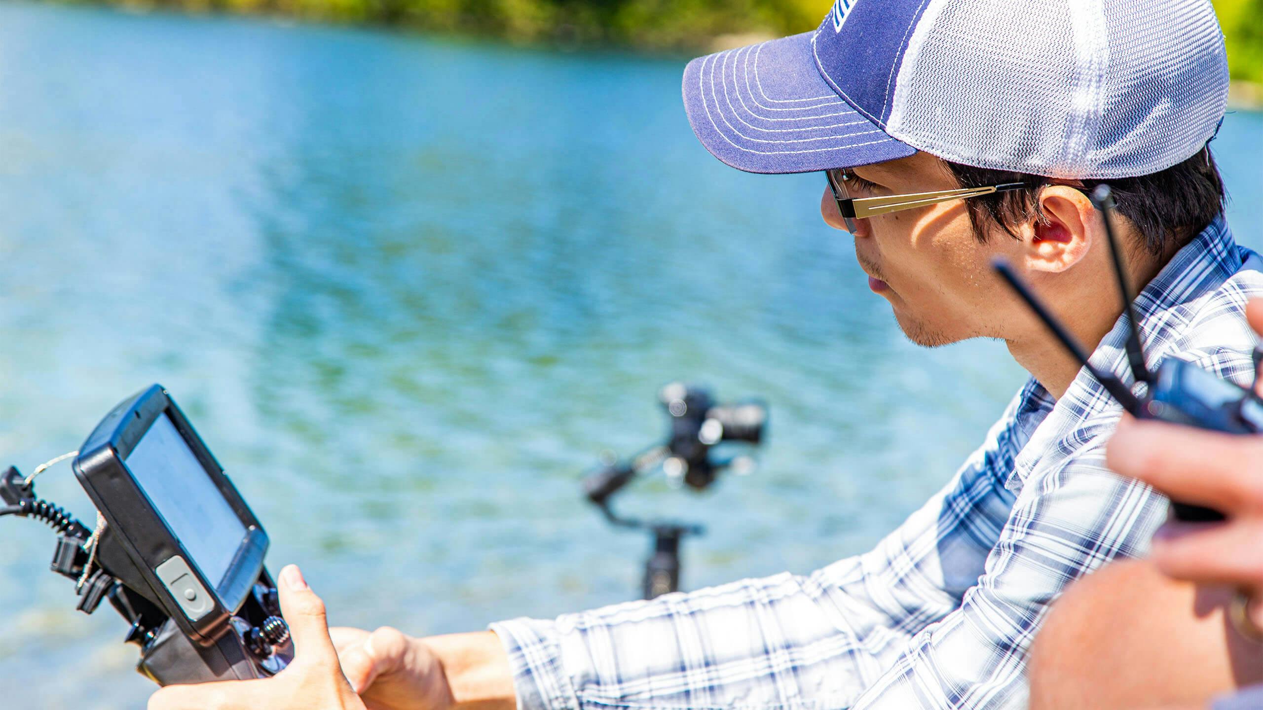
A Deep Trekker PIVOT ROV was deployed to support subsea imaging, benthic surveying, and hydrothermal activity screening in environments where direct diving is limited by temperature, depth, and safety constraints.

The unit was introduced shortly before departure after the original submersible became unavailable.
Moronke Harris described the operational pivot, “One week before the expedition began, we were devastated to learn that our original submersible would not make it to Antarctica.” The team replaced the system in under four days using coordinated logistics across multiple countries and time zones. “In just 4 whirlwind days (many emails, phone calls, text messages, and pulled strings later), we had our solution.”
The replacement system was transported through multiple international hubs before reaching Antarctic waters, where it was integrated into ongoing survey workflows alongside scuba and zodiac operations.
The ROV supported benthic imaging, hydrothermal activity detection, and ecological documentation within volcanically active and glacial marine systems.
Sarah Neill described a deployment within Port Foster, Deception Island:
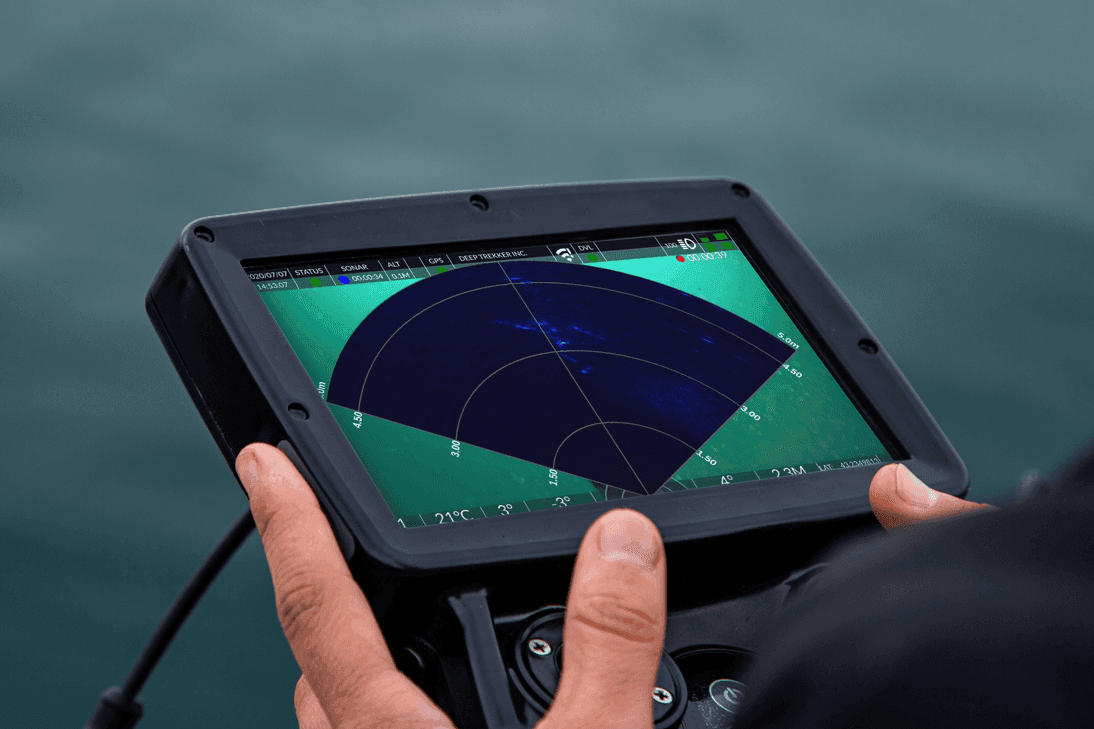
“Yesterday, the ROV team deployed a Deep Trekker Inc. PIVOT to undertake a benthic visual survey within Port Foster… The objective is to identify signs of hydrothermal vent activity within this geothermally active harbour.”
The system also captured biological datasets for research integration:
“In addition, the ROV is capturing high-resolution footage of biodiversity but also seals to support my ongoing behavioural ecology and photo-identification research.”

Scientific outputs from the ROV supported:
These datasets were later structured for integration into ArcGIS-based storytelling platforms, allowing spatial visualization of findings across the expedition track.
Discover how Natural England uses ROVs to improve marine habitat monitoring, reduce costs, and improve marine protected area surveys across the UK coastline.
GIS technology is used to convert field observations into spatial datasets and interactive maps for climate science communication and public education.
Through Esri Canada’s partnership with Sea Women Expeditions, ArcGIS Online and ArcGIS StoryMaps were used to:
Alex Miller, president of Esri Canada, described the role of mapping systems, “Maps are a universal language that transcend borders, cultures and backgrounds, making it possible for people everywhere to understand and engage with complex scientific discoveries visually.”

SWX planned to publish live maps, video updates, and educational content during and after the expedition to support ocean literacy and climate education globally.
Researchers documented physical indicators of environmental change, including glacier retreat, exposed seabed features, and newly formed coastal water bodies.
Denise Brushett described direct field observations, “You could see a lot of recent retreat. That was marked with fresh ridges and fresh boulders.” She also highlighted landscape-scale changes compared with historical datasets, noting that comparing historical maps with current conditions highlighted the extent of ice loss across the region.
Observed changes included:

These observations were incorporated into mapping workflows using GIS tools for later analysis and visualization.
The ROV operations were led by a multidisciplinary team combining marine geology, geomatics, and ocean science expertise within a women-led expedition structure.

Core contributors included:
Harris summarized the team effort:
“This was a masterclass in teamwork, trust, leading with initiative in times of uncertainty, expedition logistics, and the power of professional contacts who believe in your dreams.”
SWX leadership also emphasized the broader program structure, which integrates science, technology, engineering, arts, and mathematics (STEAM) disciplines across field operations and storytelling outputs.
Explore how Marine Science benefits from ROV technology to improve environmental monitoring and enhance research efforts for more efficient and precise results.
The expedition demonstrates how compact ROV systems are increasingly integrated into multidisciplinary polar research programs that combine field science, geospatial analysis, and public communication.

Key ROV operational advantages included:

The operation also highlighted several expedition-specific advantages that enabled the mission to proceed under compressed timelines and extreme logistical constraints. These included rapid mobilization of a replacement submersible system, international transport coordination across multiple transit points, integration with diver and zodiac-based workflows, and direct incorporation of field datasets into GIS visualization platforms for public-facing science communication.
The SWX model also extends beyond fieldwork, incorporating education and outreach programs. Since 2014, the organization has conducted multiple Arctic expeditions and engaged over 1,000 participants through training initiatives in ocean science and robotics.
Connect With Us to Support Your Next Field Mission
July 30th, 2021
Learn all about remotely operated vehicle pilots: how to become one,...
April 3rd, 2026
Learn more about what sonar is and its many uses. Read...

December 23rd, 2021
ROVs and sonar can be used to inspect underwater structures such...